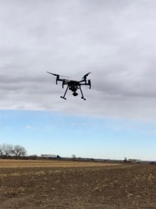
 As technology rapidly progresses, Baseline’s goal is to maintain a strong presence and adapt accordingly. One priority is to make projects more efficient for both, our clients as well as our employees. It is because of this, that in early 2020, our Survey Division purchased a drone to diversify our surveying capabilities meet the goals of our clients and their visions. The survey drone flies over any area and continuously takes 300-500 images in a 20-40 minutes time span, covering 10-40 acres at a time. Additionally, the drone system can stitch photos together, if the photos have a certain percentage of overlap, a 3D image can be generated to display contours, ground control points, and tie aerial mapping data together. Normally, a surveyor would walk in a grid pattern, but the drone supplements conventional surveying methods. Since purchasing the survey drone, Baseline has picked up a few unique projects that vary in purpose.
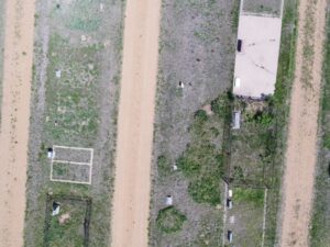 This past May, Baseline’s field crew traveled to Mount Pleasant Cemetery in Erie, Colorado, to fly the drone. This project was interesting, in that the purpose of using the drone was to observe areas where there could be unmarked graves. The key indicator of an unmarked grave is the change in ground soil covers. When an area is dug up, the disturbance in soil can prompt growth. Because the drone has the capability to capture many pictures in a condensed area, comparing photos makes it easy to identify where this change in soil has taken place as weeds will be more prevalent. The detail of these photos is so pronounced that individual dandelions can be viewed.
While Baseline works with the City of Black Hawk on several projects, one specific project required the use of the drone. Baseline’s Infrastructure and Survey Divisions teamed up to utilize the drone for mapping the roadway design along Minors Way. The drone was used to generate contours on the map, which aided in grading for construction of the road or parking lot.
According to Aaron Demo, Baseline’s survey division manager, additional opportunities that he envisions for the new survey drone includes geo-thermal inspections, solar farms, transmissions lines, building inspections for roof issues or heat loss, agricultural applications observing plant health for crop field, and storm inspections for loss of crops or insurance. Baseline’s survey team looks forward to these exciting opportunities with the new survey drone!


